
AutoNews BIM Monthly Newsletter – March 2025
AutoNews is an informational newsletter, courtesy for Robotech’s customers and followers. We hope you enjoy it and we welcome your feedback.

AutoNews is an informational newsletter, courtesy for Robotech’s customers and followers. We hope you enjoy it and we welcome your feedback.

Building Information Modeling (BIM) has revolutionized the architecture, engineering, and construction (AEC) industry by enabling more efficient project management, improved collaboration, and enhanced visualization. However, despite its proven benefits, many firms face significant hurdles when attempting to adopt BIM effectively. These challenges range from high initial costs and resistance to change, to a lack of skilled personnel and interoperability issues. Fortunately, there are practical solutions that can help firms navigate these obstacles and fully leverage the potential of BIM.

One of the most common barriers to BIM adoption is the high upfront cost. Implementing BIM requires investment in software, hardware, and training, which can be daunting for smaller firms or those with limited budgets. To address this, firms can consider phased implementation. Instead of adopting BIM across all projects simultaneously, they can start with pilot projects to demonstrate ROI and build confidence in the technology. Additionally, firms can explore subscription-based software models, which reduce initial costs and provide access to regular updates and support. According to GeoWeek News, this approach allows firms to gradually scale their BIM capabilities without overwhelming their financial resources.
Another significant challenge is resistance to change, particularly from employees accustomed to traditional methods. Change management is critical in overcoming this hurdle. Firms should focus on clear communication about the benefits of BIM, such as improved efficiency, reduced errors, and enhanced collaboration. Providing comprehensive training programs and involving employees in the transition process can also foster buy-in. As highlighted by TaalTech, creating a culture of innovation and continuous learning is essential for successful BIM adoption. Leadership must champion the change and demonstrate a commitment to supporting staff throughout the transition.
A lack of skilled personnel is another obstacle that can impede BIM adoption. BIM requires specialized knowledge and expertise, which may not be readily available within a firm. To address this, firms can invest in training programs to upskill existing employees. Partnering with educational institutions or industry organizations can also help bridge the skills gap. Additionally, hiring experienced BIM professionals or consultants can provide the necessary expertise to guide the implementation process.
Interoperability issues between different software platforms can also hinder BIM adoption. Incompatible file formats and data exchange problems can disrupt workflows and reduce efficiency. To overcome this, firms should prioritize the use of open standards, such as Industry Foundation Classes (IFC), which facilitate seamless data exchange between different software applications. Additionally, investing in software solutions that offer robust interoperability features can help streamline collaboration across teams and disciplines.
Another practical solution is to establish clear BIM standards and protocols. Without standardized processes, firms risk inconsistent implementation and miscommunication. Developing a BIM execution plan (BEP) can help define roles, responsibilities, and workflows, ensuring that all stakeholders are aligned. This plan should outline the level of detail required at each project stage, as well as the specific deliverables. By setting clear expectations and guidelines, firms can minimize confusion and maximize the benefits of BIM.
Finally, firms should leverage the power of collaboration and partnerships. BIM adoption is not just about technology; it’s about fostering a collaborative environment where all stakeholders work together toward a common goal. Engaging with clients, contractors, and suppliers early in the project can help align expectations and ensure that everyone is on the same page. Cloud-based BIM platforms can further enhance collaboration by enabling real-time access to project data and facilitating communication across teams.
Adopting Revit Within Architectural Firms
When it comes to adopting BIM within architectural firms, Autodesk Revit is often the software of choice due to its robust features and widespread use in the industry. However, the challenges of BIM adoption—such as high costs, resistance to change, and a lack of skilled personnel—are equally applicable to Revit implementation. To successfully integrate Revit into their workflows, architectural firms can apply the same practical solutions discussed earlier. Starting with pilot projects, investing in training, and fostering a culture of collaboration can help firms overcome these hurdles and fully realize the benefits of Revit. By addressing these challenges head-on, architectural firms can position themselves for long-term success in an increasingly digital and competitive industry.


The future of Building Information Modeling (BIM) is not what we traditionally envision. As the construction and design industries evolve, the tools and methodologies we use are undergoing a radical transformation. According to a thought-provoking article on Autodesk University, the future of BIM will not be BIM as we know it today. Instead, it will be a more advanced, integrated, and intelligent system that leverages the growing capabilities of computers and machines. This shift is being driven by advancements in generative design, artificial intelligence (AI), and machine learning, which are enabling machines to take on increasingly complex design tasks. The result is a future where human creativity is augmented by computational power, leading to unprecedented levels of efficiency, innovation, and sustainability in the built environment.
Generative design is at the forefront of this transformation. Unlike traditional design processes, which rely heavily on human intuition and iterative manual adjustments, generative design uses algorithms to explore countless design possibilities based on specified parameters and constraints. By inputting goals such as material usage, structural performance, and environmental impact, designers can harness the computational power of machines to generate optimized solutions that might never have been conceived through conventional methods. This approach not only accelerates the design process but also uncovers innovative solutions that balance multiple competing factors, such as cost, aesthetics, and functionality. As generative design tools become more sophisticated, they are poised to redefine the role of designers, shifting their focus from manual creation to strategic decision-making.
The growing design abilities of computers and machines are a key driver of this evolution. Modern AI systems can analyze vast amounts of data, identify patterns, and make predictions with a level of speed and accuracy that far surpasses human capabilities. In the context of BIM, this means that machines can now assist in tasks such as clash detection, energy modeling, and even the generation of construction schedules. For example, AI-powered tools can automatically identify potential conflicts between architectural, structural, and MEP (mechanical, electrical, and plumbing) systems, reducing the risk of errors and rework during construction. Similarly, machine learning algorithms can optimize building performance by analyzing historical data and simulating various scenarios to determine the most efficient design solutions.
One of the most exciting aspects of this technological shift is its potential to democratize design. As generative design and AI tools become more accessible, they empower a broader range of stakeholders to participate in the design process. Architects, engineers, contractors, and even clients can collaborate more effectively by leveraging these tools to explore design options, evaluate trade-offs, and make informed decisions. This collaborative approach not only improves the quality of the final design but also fosters a more inclusive and transparent decision-making process. Furthermore, by automating routine tasks and streamlining workflows, these technologies free up professionals to focus on higher-level strategic thinking and creative problem-solving.
Sustainability is another area where the future of BIM and generative design holds immense promise. As the global construction industry faces increasing pressure to reduce its environmental impact, these technologies offer powerful tools for creating more sustainable buildings and infrastructure. Generative design can optimize material usage, minimize waste, and enhance energy efficiency by exploring designs that balance performance with environmental considerations. For instance, algorithms can generate building forms that maximize natural light and ventilation, reducing the need for artificial lighting and HVAC systems. Similarly, AI-driven analysis can identify opportunities for incorporating renewable energy sources, such as solar panels or wind turbines, into the design. By integrating sustainability into the design process from the outset, these technologies enable the creation of buildings that are not only functional and aesthetically pleasing but also environmentally responsible.
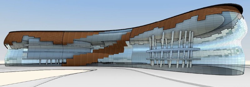
Combining Autodesk FormIt and Dynamo. Courtesy of Autodesk.
The integration of BIM with other emerging technologies, such as the Internet of Things (IoT) and digital twins, further amplifies its potential. Digital twins, which are virtual replicas of physical assets, enable real-time monitoring and analysis of building performance throughout its lifecycle. When combined with generative design and AI, digital twins can provide valuable insights that inform ongoing optimization and maintenance. For example, sensors embedded in a building can collect data on energy usage, occupancy patterns, and environmental conditions, which can then be analyzed to identify opportunities for improvement. This feedback loop between the physical and digital worlds creates a dynamic and responsive design process that continuously evolves to meet changing needs and conditions.Despite the many benefits of these advancements, their adoption also raises important questions about the future of work in the design and construction industries. As machines take on more design tasks, there is a growing need for professionals to develop new skills and adapt to changing roles. Rather than replacing human designers, these technologies are likely to augment their capabilities, enabling them to tackle more complex and ambitious projects. However, this transition will require a shift in mindset, as well as investment in education and training to ensure that the workforce is equipped to harness the full potential of these tools. Additionally, ethical considerations, such as data privacy and algorithmic bias, must be addressed to ensure that these technologies are used responsibly and equitably.
The future of BIM is not just an incremental improvement on existing practices; it is a fundamental reimagining of how we design and construct the built environment. Generative design, AI, and other emerging technologies are transforming the way we approach design, enabling us to create smarter, more sustainable, and more innovative solutions. As these tools continue to evolve, they will empower designers to push the boundaries of what is possible, while also addressing some of the most pressing challenges facing the construction industry. The future of BIM is coming faster than we think, and it promises to be a future where human creativity and machine intelligence work hand in hand to shape a better world.
Interested in seeing the power of BIM in your office?
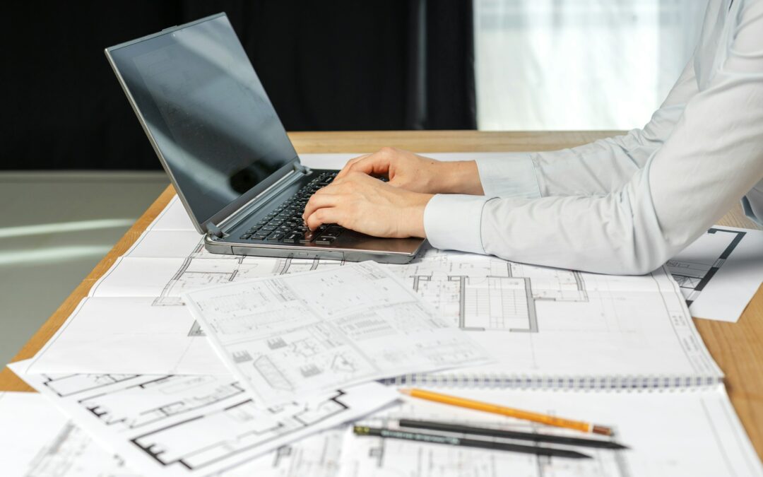
The architecture, engineering, and construction (AEC) industry has undergone a seismic shift over the past few decades, driven by the evolution of technology from Computer-Aided Design (CAD) to Building Information Modeling (BIM). This transformation has not only revolutionized how buildings are designed and constructed but has also redefined collaboration, efficiency, and sustainability in the industry. From the early days of 2D drafting to the sophisticated 3D modeling and data-rich environments of today, the journey from CAD to BIM is a testament to the power of innovation in shaping the future of construction.

1960s: The Birth of CAD
The story begins in the 1960s, when the first CAD systems emerged. These early tools, such as Sketchpad developed by Ivan Sutherland, allowed designers to create digital 2D drawings. While revolutionary at the time, these systems were limited in scope and required significant computational power, which was expensive and inaccessible to most.
1980s: The Rise of 2D CAD
By the 1980s, CAD software became more accessible and widely adopted. Programs like AutoCAD, introduced by Autodesk in 1982, enabled architects and engineers to create precise 2D drawings more efficiently than manual drafting. This era marked the beginning of the digital transformation in the AEC industry, as firms began to transition from paper-based workflows to digital ones.
1990s: The Emergence of 3D Modeling
The 1990s saw the introduction of 3D modeling capabilities in CAD software. Tools like Autodesk’s 3D Studio and Bentley Systems’ MicroStation allowed designers to create three-dimensional representations of buildings. While this was a significant step forward, these early 3D models were primarily visual and lacked the data-rich features that define modern BIM.
2000s: The Dawn of BIM
The concept of BIM began to take shape in the early 2000s. Unlike traditional CAD, BIM is not just about creating drawings or models; it’s about creating a digital representation of a building that includes both geometric and non-geometric data. Autodesk Revit, launched in 2000, was one of the first BIM platforms to gain widespread adoption. Revit allowed architects, engineers, and contractors to collaborate on a shared model, integrating design, construction, and operational data into a single platform.
2010s: BIM Goes Mainstream
The 2010s marked the mainstream adoption of BIM across the AEC industry. Governments and organizations worldwide began mandating BIM for public projects, recognizing its potential to improve efficiency, reduce errors, and enhance collaboration. During this time, Autodesk Revit continued to evolve, adding features like parametric modeling, cloud collaboration, and integration with other tools such as Navisworks for clash detection and analysis.
2020s: BIM and Beyond
Today, BIM is no longer just a tool but a foundational element of the AEC workflow. The integration of BIM with emerging technologies like artificial intelligence (AI), virtual reality (VR), and the Internet of Things (IoT) is pushing the boundaries of what’s possible. For example, AI-powered tools can now analyze BIM data to optimize building performance, while VR allows stakeholders to visualize and interact with BIM models in immersive environments.
BIM has become indispensable to the AEC industry, transforming how projects are planned, designed, constructed, and managed. Unlike traditional CAD, which focuses primarily on geometry, BIM provides a holistic approach by embedding critical data into every component of a building model. This data-driven methodology enables better decision-making, reduces errors, and improves collaboration among stakeholders.
One of the standout BIM platforms in the industry is Autodesk Revit. Revit’s robust features, such as parametric modeling, real-time collaboration, and interoperability with other software, make it an ideal choice for architects, engineers, and contractors. Its ability to create detailed, data-rich models ensures that all project stakeholders are working from the same information, minimizing misunderstandings and rework. Furthermore, Revit’s integration with Autodesk’s ecosystem, including tools like BIM 360 for cloud-based collaboration, enhances its utility in modern construction projects.
The evolution from CAD to BIM represents more than just a technological shift; it signifies a fundamental change in how the AEC industry approaches building design and construction. BIM’s ability to integrate data, improve collaboration, and enhance efficiency has made it an essential tool for modern construction projects. As the industry continues to embrace digital transformation, platforms like Autodesk Revit will play a pivotal role in shaping the future of construction, enabling smarter, more sustainable, and more innovative buildings. The journey from CAD to BIM is far from over, and the possibilities for what comes next are as exciting as the progress we’ve already made.

AutoNews is an informational newsletter, courtesy for Robotech’s customers and followers. We hope you enjoy it and we welcome your feedback.


In the world of Architecture, Engineering, and Construction (AEC), the importance of seamless coordination across various design functions and disciplines cannot be overstated. Properly aligned workflows can transform project outcomes, significantly improving efficiency and minimizing the need for multiple design iterations. With advanced tools like BIM Collaborate Pro, an Autodesk Construction Cloud (ACC) product, design coordination has entered a new era, enabling projects to be managed with greater precision, security, and traceability. The following video explores how BIM Collaborate Pro facilitates this coordination process, ensuring that every discipline can collaborate seamlessly while enhancing project quality. Watch it now to see how advanced design coordination can transform AEC project workflows.
A well-structured review process through design coordination is key to achieving large efficiency gains. Establishing this process at both the company and project levels is critical for effective collaboration, ensuring that every discipline adheres to project standards and procedures from the beginning. This approach enables various teams, each contributing their specialized expertise, to work cohesively within a shared framework. As a result, it reduces rework and streamlines the journey toward the final design.
Large-scale construction projects often involve multiple companies, each contributing specialized data for their respective design disciplines. Effective project-level coordination facilitates this collaboration by enabling secure data sharing among these companies. This involves creating a robust environment where each discipline can exchange information with stakeholders while also managing their internal data-sharing needs.
Using BIM Collaborate Pro, companies can create a shared coordination space specifically for this purpose. The shared coordination space acts as a controlled environment where design data can be securely shared and managed, enhancing both security and traceability. Additionally, the platform’s clash detection features enable teams to identify and resolve potential issues early on, ensuring a smoother path to project completion.
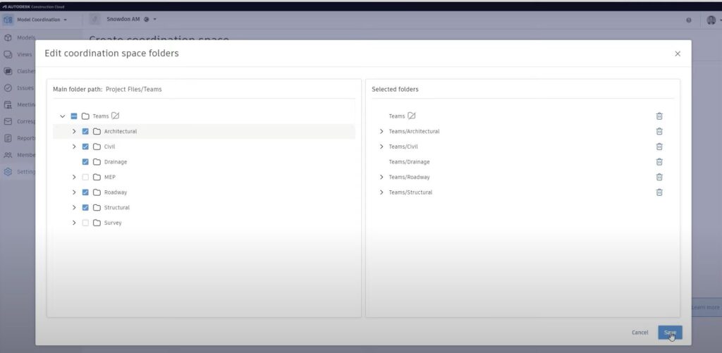
Within each company, design disciplines need a collaborative framework to refine their designs and optimize quality before sharing with other project stakeholders. BIM Collaborate Pro allows companies to set up dedicated coordination spaces, where teams can run internal clash checks and coordinate data among internal disciplines, such as architectural, structural, and MEP. By using live connections for data sharing, these internal teams can ensure that each design aspect aligns well before it is integrated at the project level.
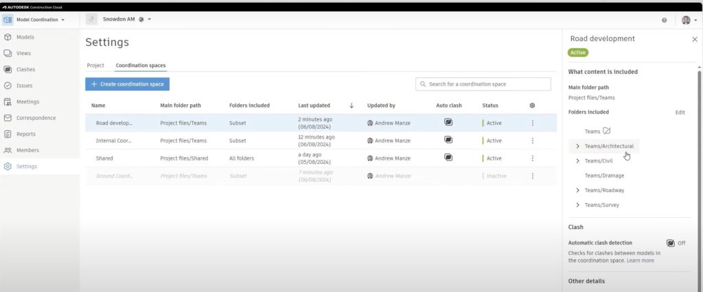
Setting up a project within ACC often starts with the use of project templates. These templates store critical project parameters, standards, and member permissions, allowing for consistent setup across projects. By defining permissions at a folder level, project administrators can control access based on team roles, ensuring that collaborators only interact with the data they need. This security-first approach is crucial for maintaining control over sensitive project information.
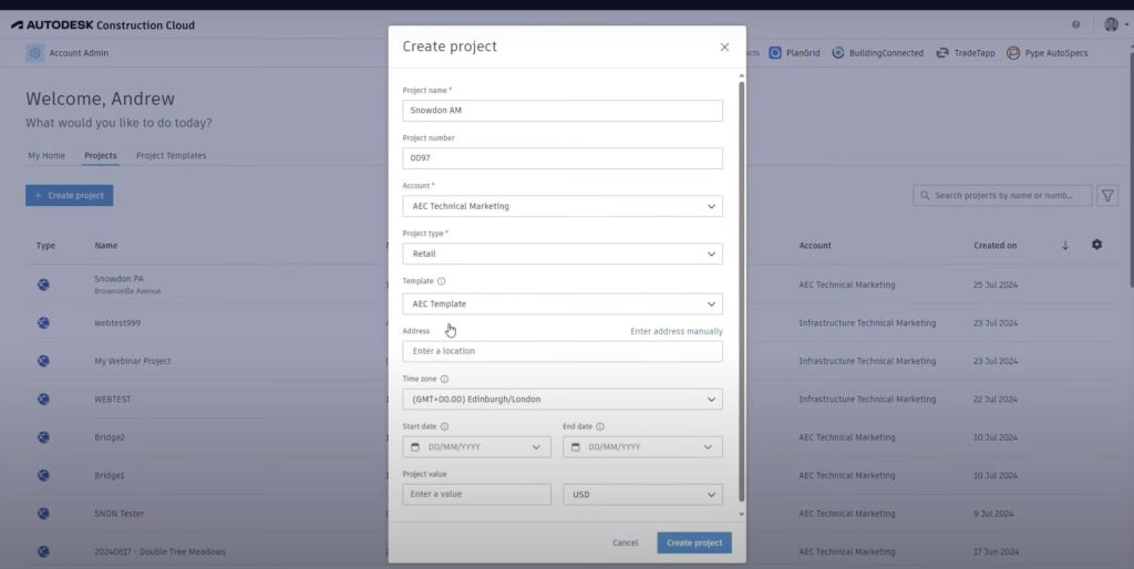
“The refined standard project management folder structure and templates intuitively caused project participants to explore the use of all available modules, reducing management by email and spreadsheets.”
– Ann Blanchard, Senior Project Manager, Arcadis
Every construction project evolves, and the BIM Collaborate Pro coordination spaces are designed to adapt to these changes. For example, new coordination spaces can be added, and existing ones can be adjusted by modifying content folders, enabling clash detection, or even renaming the spaces as project needs shift. This flexibility ensures that the coordination setup remains relevant and useful throughout the project lifecycle.
Design collaboration workflows within the Autodesk Construction Cloud streamline data sharing across companies. Here’s how it works. Once a design team—say the structural team—creates a data package, it is shared along a project timeline. The MEP team, working within the same environment, can then explore this structural data. If they find it necessary for their designs, they “consume” the data, bringing it into their own data structures to inform their design decisions. This shared workflow not only enhances coordination, but also maintains a record of interactions, ensuring traceable and reliable data exchanges.
Effective issue management is vital in collaborative projects. When clashes or concerns arise, they can be tracked and resolved within Autodesk Construction Cloud. For example, if a clash is detected between structural and MEP data, an issue is raised and assigned to the relevant team, with responsible members and response timelines prepopulated via templates. This structured approach enables team members to address issues promptly, redesign as needed, and re-share updated models, keeping all stakeholders informed throughout the resolution process.
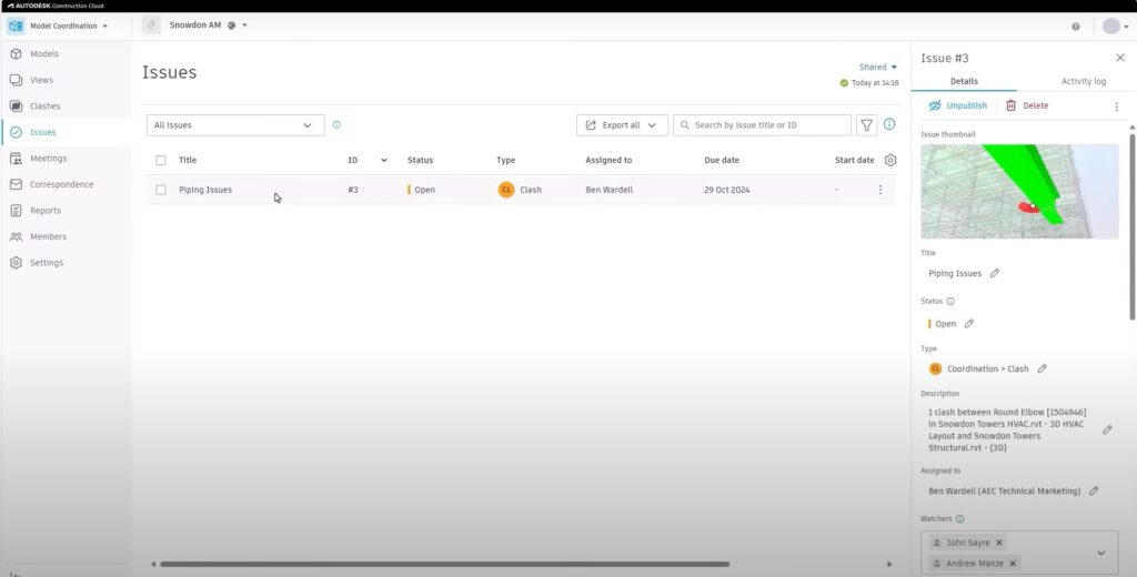
BIM Collaborate Pro, paired with the AEC Collection, empowers design and construction teams to elevate operational efficiency through advanced workflows. By enabling coordinated, flexible, and secure project environments, these tools help teams work more effectively, reduce rework, and ultimately deliver better project outcomes.
Incorporating design coordination with BIM Collaborate Pro into your projects can streamline your team’s workflows, minimize costly errors, and enable more efficient project delivery. With coordination at both company and project levels, teams are set up for success from day one.
If you’re new to Autodesk or want to get this software today, our team at Robotech can help. We offer comprehensive entry-level basics training, and we sell Autodesk software directly to companies across the country. We are a gold partner of Autodesk, and we’ll ensure your team is fully set up and comfortable with the software before we consider the job “done”.
We have a few Autodesk packages that we offer, and we can provide a free trial for you to test it before you buy. Within a few minutes, you’ll see how helpful this software is in maintaining your healthcare compliance accreditation.